New Straitsville Section

Trail Alerts   •    Map Updates   •    Trail Towns   •    Section Blog


Burr Oak Lake. Richard Lutz

Supervisor: Anne Furste

61.7 Total Miles / 38.3 Off Road Miles (62%)
Map Publication Date: November 2018

The trail enters the New Straitsville Section from a high hill on SR 78 northeast of Burr Oak Lake. It exits the section from Boch Hollow State Nature Preserve onto SR 664 some 250 ft lower. But, along the way, it undulates over 12,000 ft. You will visit extensive lengths of footpath within Burr Oak State Park and the Wayne National Forest. Whether off road or not, trail within the Wallace O‘Dowd State Wildlife Area is quite remote. The entire region is characterized by rolling wooded hills with numerous streams and beaver activity. Deer, turkey and other animals may be seen on this hike.
Public camp grounds are available at Burr Oak Boat Docks 2 and 3. Camping in the Wayne National Forest is permitted but follow primitive no trace practice. During the summer months, many of the streams are dry. Pack plenty of water. Shawnee, OH, hosts the only restaurant, as well as the BTA Office. In 2024, the trail was rerouted to pass through Shawnee after leaving Tecumseh Lake.

Trail Alerts

  • (6/30/25) This Trail Alert was reported by the Section Supervisor, Anne Furste. There is a bridge out between New Straitsville Point 22 and 23 just east of Rock Run Rd. The creek is fordable.

    This alert applies to all BTA map products — the printed Section maps as well as the FarOut and Avenza apps.

Map Updates

  • (9/2/25) This new update is for New Straitsville Pts 14-16 with a move of Pt 15 from the junction of Fox Hunter Rd and Antle Orchard Rd. Pt 15 is now located only 200’ to the west of its former location and is where new off-road trail crosses Antle Orchard Rd.

    The update adds 0.3 mi from Pt 14 to Pt 16, but removes 1.2 mi of road walk with new off-road trail. Only 0.3 mi of road walk remains. The mileage change from Pt.14 to Pt 15 is negligible. However, for those with the New Straitsville printed map dated 2018, please add 0.3 mi to the CW mileages from Pt 16 and higher. Add 0.3 mi to the CCW mileages from Pt. 15 and lower.
    This map update applies to all BTA map products.

    The new descriptions for the updated points are below:
    • 14. SR 13 Bridge across Sunday Creek
      CW 17.0 CW 44.7

      Continue S on SR 13 around the end of the guard rail. Head W into the WNF on a footpath that will meander over a major ridge. After 2.1 mi, ford Long Run. Ascend a second ridge with similar aimlessness. After 0.8 mi, cross a fenced segment (0.1 mi) of private property. Head S on an old abandoned road. The trail will turn in a SW direction and meander through a series of ravines for about a mile before exiting onto Antle Orchard Rd (C87).
    • 15. Footpath at Antle Orchard Rd (C87)
      CW 20.9 CCW 40.8

      Cross Antle Orchard Rd and travel in a SW direction along a steep ravine, passing a waterfall and recessed cave rock formations on your way to Oakdale Rd. The blue paint on trees indicates an EPA water protection zone, nothing should be discarded into this zone. (Leave No Trace). Turn right on Oakdale Rd (c31) and continue W.
    • 16. Oakdale Rd (C31) at Antle Orchard Rd (C87)
      CW 22.0 CCW 39.7

      Continue N on Oakdale Rd past Antle Orchard Rd which exits (SE). Pass through McLeish. After 0.4 mi, exit Oakdale Rd that continues N. Turn W onto an unmarked, former township road into the Wallace O’Dowd Wildlife Area. Continue on similar roads for 3 mi through the wildlife area.
    • 17. T312 at Hunterdon Rd (T92)
      CW 25.0 CCW 36.7

      Continue as noted in your BTA map product.


  • (7/2/25) New Straitsville - Pt 34 Boch Hollow State Nature Preserve on SR 664 – West Trailhead. The this location now offers a Day use parking area of 19 spaces. This update applies to all BTA map products.


  • (6/14/25) A change was made by the trail crew in the New Straitsville Section between Pts 22 and 23. As a result, the description for Pt 22 changes to reflect the physical change. This map update applies to the 2018 BTA printed New Straitsville map and to the current Avenza and FarOut app versions of the BT. The Section increased by 0.2 miles making it 61.4 miles. For CW Points numbered 23 and higher add 0.2 miles to the trail distance. For CCW Points numbered 22 and lower, add 0.2 miles to the trail distance. The revised description is as follows:

    Pt 22 Tecumseh Lake, Facilities: (P) No overnight parking; CW 39.7 CCW 23.5

    Follow blue blazes across dam, turn N onto SR 93, and at the 4-way STOP, continue into the Village of Shawnee (MM,P,R,W,E, BTA Office) Overnight parking on Main St. Turn left on Main St and continue 0.6mi W, passing the BTA office in 324ft on your left. Just past Shawnee Mission Church turn left. On your right you will see a brown garage with a blue blaze on the back door. Inside are two wooden bunks, electricity, and some bottled water. Cross SR 93 at carsonite post and turn left. Follow blazes and continue in SR 93 right of way until just past a gas station. Turn right onto Upson Hollow Rd (T438). To the left is a dirt road leading to a private campground that provides parking and a pit toilet. Call Zach (740-603-8155) to reserve.

    After 0.2mi on Upson Hollow Rd, the trail will turn right and enter the woods through a private property easement. Continue NW initially, then into the Wayne National Forest (0.4mi) before ending up in a beautiful, reclaimed strip mine, crossing limestone rocks battling acid mine drainage with a waterfall off to the left. Descend to Rock Run Rd (0.27mi, T41). Cross Rock Run Rd and follow the trail NW through a beautiful hollow, crossing a small creek before ascending a hillside. Turn W after 0.5 mi through a white pine forest on footpath. In 0.45mi, turn NW onto Old Town Rd (C38), cross Monday Creek (450’), pass (T190, exits SW), and turn NE with Old Town Rd.

    Pt 23 Entrance to Old Stone Church Trailhead CW 42.2 CCW 19.2

  • (12/18/24) This map update for New Straitsvile applies to the 2018 BTA printed map and to the current Avenza and FarOut app version of the BT. Ann Furste, Section Supervisor, and her trail crew made several trail changes from Point 19 to Point 23. Point 20 has moved 0.1 mi north and new trail was built between Points 20, 21, and 22. From Point 22 to 23, the trail was routed through the Village of Shawnee, home of the BTA office, and two new camping locations were added. The total mileage of the section increased to 61.2 mi. This update also incorporates a former update dated 11-10-2024 for Point 22 (which was removed) identifying the trail change from Point 22 to Point 23 through Shawnee. See the trail log below:
    CW CCW Pt Description
    27.8
    N
    34.4
    E
    19.SR 78 at SR 216 in Murray City
    Facilities: MM, PO: 43144.
    Follow BT mostly N on SR 216. Notice the large number of sealed drift mines beneath massive sandstone cliffs in Murray City. After 0.5 mi, where SR 216 turns more NW, continue N on Salem Rd. After 1.9 mi, pass Salem Cemetery. After 0.9 mi, cross into Perry Cty from Hocking Cty. Here, T21 becomes T18 but, if you are hiking, that is an unimportant technicality. Continue NW
    32.4
    W
    28.8
    SE
    20.Salem Rd (T18) at Footpath
    Exit Salem Rd (T18) left and immediately cross a usually dry creek bed. Follow the BT in a generally S and then W direction up and around multiple ridges. Cross an old forest road (0.6 mi), descend to cross first one creek, then another. After the second creek crossing, follow the trail and the creek bed in NW direction to cross T427 (0.7 mi from 2nd creek crossing). Cross T427 and continue N to Salem Hollow Rd (C17).
    35.2
    N
    28.8
    S
    21.160 ft W on Salem Hollow Rd (C17) from Intersection at T18 and T427
    Follow trail another .21 mi as it turns first E, N, E and finally W. Continue 1.12 mi, meandering and ascending gradually through dense forest, passing an old oil pump, and descending down to Upper Rock Run (Mine Fire Trailhead) with several trail junctions. In 0.73 miles after following blue-blazed Carsonite posts to where the trail enters woods, ascending again through dense forest, and eventually crossing a service road under a utility line, cross Salem Hollow Rd (C17). Now descend, sometimes steeply, until you reach Tecumseh Lake (0.3mi, Point 22).
    37.9
    N
    23.3
    S
    22.Tecumseh Lake
    Facilities: (P) No overnight parking;
    Follow blue blazes across dam, turn N onto SR 93, and at the 4-way STOP, continue into the Village of Shawnee (MM,P,R,W,E, BTA Office) Overnight parking on Main St. Turn left on Main St and continue 0.6mi W, passing the BTA office in 324ft on your left. Just past Shawnee Mission Church turn left. On your right you will see a brown garage with a blue blaze on the back door. Inside are two wooden bunks, electricity, and some bottled water. Cross SR 93 at carsonite post and turn left. Follow blazes and continue in SR 93 right of way until just past a gas station. Turn right onto Upson Hollow Rd (T438). To the left is a dirt road leading to a private campground that provides parking and a pit toilet. Call Zach (740-603-8155) to reserve.
    After 0.2mi on Upson Hollow Rd, the trail will turn right and enter the woods through a private property easement. Continue NW initially, then into the Wayne National Forest (0.4mi) before ending up in a beautiful, reclaimed strip mine, crossing limestone rocks battling acid mine drainage with a waterfall off to the left. Descend to Rock Run Rd (0.27mi, T41). Go NW on Rock Run Rd for 0.11mi before making a short, steep climb on an unused access road that parallels Rock Run. After 0.2mi leave the old access road and turn W through a white pine forest on footpath. In 0.45mi, turn NW onto Old Town Rd (C38), cross Monday Creek (450’), pass (T190, exits SW), and turn NE with Old Town Rd.
    44.01.123.Entrance to Old Stone Church Trailhead

  • (1/6/24)Updates between Points 23 and 27

    This trail update applies to the November 2018 New Straitsville map with previous Map Updates dated 10/2019 and 06/2023 having been applied, and affects Point 23 to Point 27. 3 separate trail reroutes were opened with the net effect of avoiding some deeply rutted service roads and bridle trail, moving the BT much closer to the NCNST Trailhead/parking area on T190, and reducing the New Straitsville section's total length by 1.6 miles. For CW Points 27 and higher subtract 1.6 mi. For CCW Points 23 and lower subtract 1.6 mi. The new values are: Total Length: 60.6 mi, Off-road Length: 36.9 mi, Proportion: 60.9%. The new section-point descriptions are as follows:

    CW CCW Pt Description
    41.5
    NE
    19.1
    SW
    23Entrance to Old Stone Church Traihead
    Exit Old Town Rd (C38). Enter Old Stone Church Traihead on drive. Go to N end of loop drive. Follow BT on bridle trail for 1.4 miles heading N and then generally NW before turning S where bridle trail connects to a service road [39.616872 N, 82.263613 W]. Follow service road for approx. 0.32 mi and come to a 4x4 post. Turn S onto another service road. Note- these service roads are Stone Church Horseback Riding System trails. Follow this for 140ft then go SE onto hiker-only trail, 39.613718 -82.265296, continue 0.2 miles SE until reaching a junction with T190.
    43.6
    S
    17.0
    N
    24Stone steps at T190 road crossing
    Proceed across T190 on hiker-only trail which goes W and S for 0.31 miles until it rejoins service road/bridle trail at a 4x4 post 39.609108, -82.266333. Continue SW on footpath that descends before turning N on an abandoned road just above wetlands associated with Salt Run. After 0.8 miles at 39.614842, -82.272561 arrive at T190. Proceed across T190 onto hiker-only trail that continues for 0.17 miles N then turns W and rejoins T190 at a creek crossing.
    44.9
    W
    15.7
    E
    25T190 Bridge over Salt Run
    Continue SW on T190 for 190ft then turn N onto hiker-only trail into woods, proceed 270ft until junction with Stone Church Long Loop bridle trail. Take a sharp turn to SW on the bridle trail and continue for 0.18 miles back down to T190. Cross T190 and continue S on bridle trail. After 0.12 miles turn W onto ATV road. After 160ft turn SW as bridle trail continues uphill. This stretch comes out of woods into pastureland, and after 0.4 mi arrives at a junction, 39.614910, -82.282442 with a spur trail. The main BT continues straight here; you are at Pt 26. Note: This spur trail goes NW for 0.16 miles and ends at the North Country National Scenic Trail trailhead/grass parking area at 39.615987 , -82.285180, which is on the T190 road.
    45.7
    SW
    14.9
    E
    26 NCNST Trailhead Spur Trail
    A sign marks the beginning of the spur trail that goes NW for 0.16 miles and ends at the North Country National Scenic Trail trailhead/grass parking area at 39.615987, -82.285180. This parking area is on T190. The main BT continues past the spur trail junction W then SW for 0.55 mi where it meets the hiker-only Imhoff Preserve trail at 39.610543,-82.287398. Continue S, after 0.35 mi cross an intermittent stream. Ascend across an old township road T242 (0.11 mi). Continue on this trail as it meanders and undulates into the valley of Dan's Run.
    47.7
    NNW
    12.9
    ENE
    27 BT at T305
    Note: this description remains the same as in the 10/28/19 map update. Location: 39.60084, -82.29453. Continue NNW on footpath that will ford Dan's Run (250ft) and cross an old logging road (150ft). After 0.2 mi at a 3-way trail intersection, pass a footpath that exits W to BTA’s Imhoff Preserve Campsite. After 0.45 mi, reach a dirt road (T241) with space for parking 2 vehicles on a very short drive off the E side of the road. Turn NNW onto T241 and continue on road. After 1.0 mi, reach Dutch Ridge Rd (C7). Join Dutch Ridge Rd and head SW.

  • (6/14/23)Update at Point 21

    This trail update applies to the November 2018 New Straitsville map and affects Point 21 to Point 22. A staircase was added along Salem Hollow Rd and the trail has been rerouted through up stream Rock Run and Tecumseh Lake. The reroute adds 0.4 mi to the section for a total of 62.2 mi. For CW Points 22 and higher add 0.4 mi. For CCW Points 21 and lower add 0.4 mi. The new description is as follows:

    • Point 21 160 ft W on Salem Hollow Rd (C17) from Intersection at T18 and T427. CW 34.7 N CCW 27.5 S
      Follow trail another .21 mi as it turns first E, N, E and finally W. Continue 1.12 mi, meandering and ascending gradually through dense forest, passing an old oil pump, and descending down to Upper Rock Run (Mine Fire Trailhead) with several trail junctions. In 0.73 miles after following blue-blazed Carsonite posts to where the trail enters woods, ascending again through dense forest, and eventually crossing a service road under a utility line, cross Salem Hollow Rd (C17). Now descend, sometimes steeply, until you reach Tecumseh Lake (0.3mi, Point 22).

    • Point 22 Tecumseh Lake CW 37.4 SW CCW 24.8 SE
  • (1/29/23)Trail Update for New Straitsville

    During the data book update process, an error was found in a waypoint description. At Pt 22, the second set of waypoints is incorrect and should read as follows:
    After 0.45 mi at (39.60545 degrees N, 82.24985 degrees W), turn NW onto Old Town Rd (C38) across Monday Creek (450’).

  • (10/28/19)Trail Change for New Straitsville

    This Map Update announces both the opening of new trail across BTA’s Imhoff Preserve and adjoining Wayne National Forest properties and an Adirondack-style shelter within BTA’s Imhoff Preserve. The changes occurred to the trail described between Pt 27 and 29 in the latest New Straitsville Section map (Edition of November 2018).

    As a result of the change in route, the trail no longer reaches Pt 28 (T242 at Dutch Ridge Rd (C7)) and the distance between Pt 27 and 29 has been reduced by about 0.1 mi. In addition, both the reduction of overall trail length and the new off-road trail have changed the proportion of trail off-road. The new values are: Total Length: 61.8 mi, Off-road Length: 37.6 mi, Proportion: 60.9%

    CW CCW Pt Description
    48.9
    NNW
    12.9
    ENE
    27. BT at T305
    Location: N 39.60084, W 82.29453. Continue NNW on footpath that will ford Dan's Run (250’) and cross an old logging road (150’). After 0.2 mi at a 3-way trail intersection, pass a footpath that exits W to BTA’s Imhoff Preserve Campsite. After 0.45 mi, reach a dirt road (T241) with space for parking 2 vehicles on a very short drive off the E side of the road. Turn NNW onto T241 and continue on road. After 1.0 mi, reach Dutch Ridge Rd (C7). Join Dutch Ridge Rd and head SW.
    51.0
    NW
    10.8
    SW
    29. Dutch Ridge Rd at T135
    Dutch Ridge Rd continues W. Turn NW onto T135. This ends the route change. Continue with the text in the November 2018 edition of your New Straitsville Section map with the minor exception that you should reduce CW distances that follow Pt 29 by 0.1 mi and reduce CCW distances that precede Pt 27 by 0.1 mi.

    Camping Along the Trail
    Add Item 5 below to the list of available campsites. In addition, change the paragraph that begins, “The Buckeye Trail Association” and replace it with the paragraph that follows Item 5 below.

    5. Between Pt 27 and 29, camp in an Adirondack-style shelter on BTA’s Imhoff Preserve. Purify water from Dan's Run. Use minimum impact techniques. To access the shelter, follow the trail 0.3 mi W from Pt 27 to a 3-way trail intersection. Take the side trail 200' W to the shelter (39.60049°N, 82.29968°W).

    The Buckeye Trail Association manages 1 campsite (See Item 5 above.) within the New Straitsville Section. Dispersed camping is not permitted on private or state lands without express permission of the owner/manager. Hikers are expected to comply with the rules in all instances.

Trail Towns

Shawnee – Trail Town Dedication October 14th, 2018

Nestled in the foothills of Appalachia in Southern Perry County is the historic coal mining village, now Trail Town, known as Shawnee. Settlers first arrived in the area around 1814, however the town government wasn’t established until 1874. This friendly little town is home to scenic views along Main Street, featuring overhanging second-story porches and unique architecture, which lends to the imagination what the quiet streets would have looked like at the turn of the century with over 4,000 residents! Today, Shawnee is home to approximately 650 people, who are descendants of the Welsh, German, Scottish, Irish, and Italian immigrants who came here in the early 1900s to work in the mines, and create homes and lives for their families.

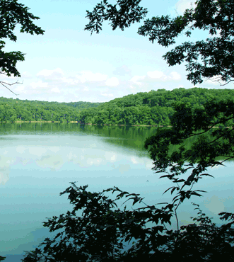
In 1952, after all mining and brick factories were shut down, local townspeople convened and decided to construct a new recreational area on the outskirts of town, with the hopes of drawing people back to the once booming city, this man-made structure is known as Tecumseh Lake. Today, the lake is still a popular destination for hikers, fishermen, and kayakers and shows that resourcefulness is not a quality that has been lost through the generations! Shawnee is home to many flourishing organizations including Destination Shawnee, Ohio Hill Country Heritage Area, Little Cities of Black Diamonds Council, and hosts the state headquarters for the Buckeye Trail Association.

Located in the heart of Wayne National Forest, Shawnee is surrounded by miles and miles of public land. Ohio’s only national forest boasts over 100,000 acres that are used for hiking trails, fishing sites, camping areas, horseback riding trails, birding areas, and ATV riding areas. As if that wasn’t enough, Shawnee is also only a quick trip away from Burr Oak State Park and Hocking Hills State Park which claims over 2,500 acres of gorgeous waterfalls, trails, caves, and more. This close proximity makes Shawnee ideal for a trip to nature, with something for everyone!

Shawnee is proud to have become a Trail Town and hopes to work closely with the Buckeye Trail Association in order to promote outdoor experiences. Thank you, we hope to see you soon!

Section Blog Posts

  • (5/21/23) New Straitsville Section Blog - Provided by Victoria Livingston, BTA hiker. Join Victoria and her husband Dave as they hiked through Boch Hollow in the New Straitsville Section. She tells about the wind symbol on cell phones and the importance of it as it reltates to hiking in the forest. Follow their adventure here when they finished in the dark.
  • (4/22/24) How to Meet New Friends Hiking the Buckeye trail We started hiking the Buckeye Trail for a new challenge and bragging rights, but we discovered that new friendships were even more important. We hiked New Straitsville #13-19 with Krista and Pat, friends we met through the Buckeye Trail, and we always laugh and have a good time hiking with them! Provided by Victoria Livingstone.