- Overview
- Akron
- Bedford
- Belle Valley
- Bowerston
- Burton
- Caesar Creek
- Defiance
- Delphos
- Loveland
- Massillon
- Medina
- Mogadore
- New Straitsville
- Norwalk
- Old Man's Cave
- Pemberville
- Road Fork
- St. Marys
- Scioto Trail
- Shawnee
- Sinking Spring
- Stockport
- Troy
- West Union
- Whipple
- Williamsburg

Bedford Section
Trail Alerts • Map Updates • Trail Towns • Section Blog
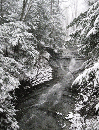
Bridal Veil Falls. Darlene Karoly
Supervisor: Bill Hines
66.5 Total Miles / 49.9 Off Road Miles (75%)
Map Publication Date: April 2022
The Bedford section begins in the Brecksville Reservation, a unit of Cleveland Metroparks (CMP), near trail access to Deer Lick Cave where three sections of the BT meet. Bedford and Akron Sections begin at this point and Medina Section ends. Although changes to the trail continue, 140’ to the west of this junction marks the point where the Buckeye Trail (BT) was formally completed in 1981 as a hiking trail in a loop that can be said to link the four corners of Ohio.
The Bedford Section goes generally northeast from Brecksville Reservation to Headlands Beach State Park on Lake Erie, the BT's most northern extension, where the trail meets the Burton Section. Along the way, the trail follows the Towpath Trail in Cuyahoga Valley National Park, and then trails through Bedford Reservation (CMP) and South Chagrin Reservation (CMP).
Although more road walking is encountered from here on, significant intervals on footpath are found within North Chagrin Reservation (CMP), Chapin Forest Reservation, a unit of Lake Metroparks (LMP), with its view of Cleveland off in the distance, Penitentiary Glen Reservation (LMP), Mentor Lagoons Nature Preserve (City of Mentor) along bluffs above Lake Erie, and Mentor Marsh State Nature Preserve where you may see nesting eagles.
Trail Alerts
- (10/14/2025) Bedford Trail Alert 10-15-2025 The Ohio Department of Transportation has announced that bridge repair of the SR 82 bridge over the Cuyahoga River has caused the closure of the Ohio & Erie Canal Towpath Trail (OECTT). This affects the BT between Pts. 3 and 5 in the Bedford Section. Repairs should complete by early November 2025 depending on the weather. The alert affects all BTA mapping products. The detour follows: CW: From Pt 3, BT crosses the Cuyahoga River on a bridge and enters Summit Cty from Cuyhaoga Cty. In 450’, BT crosses the OECTT, curves to right and ascends Pine Hill Rd (no traffic allowed). At the top, follow road to metal guardrail and cross SR 82. Go E on SR 82 for 300’ and at Chaffee Rd turn left and go N 1.5mi. At Canal Rd turn left and go NW 1.2mi to Sagamore Rd. Turn right onto Sagamore Rd and continue on blazed BT to Point 5. CCW: If you are hiking CCW on the BT from Point 5 to Point 3, when you reach Sagamore Rd and Canal Rd you would turn left (SSE) and go 1.2mi on Canal Rd to Chaffee Rd. At Chaffee Rd turn right (S); go 1.5mi to SR 82; turn right (W) onto SR 82. After 300’, cross SR 82 to Pine Hill Rd (no traffic allowed) and descend into the valley. Cross the OECTT and proceed to the Station Road Bridge crossing the Cuyahoga River to continue on the blazed BT to Point 3.
Map Updates
- (10/28/2025)Bedford map update for Pt 26 to Pt 29.
The City of Mentor requested several changes to the BT within the city. The first change allows the trail to pass through the Wildwood Cultural Center property which has wooded trails. This change takes the BT on a road with less traffic, a wide berm, and parking. The second change takes the BT through the Mentor Civic Center campus. The Civic Center area also offers ample parking.
As a result of these changes, Pt. 27 and Pt 28 move to new locations. And the length of the Bedford Section increases by 0.8 mi changing the Bedford Section to a total of 67.0 mi.
On the BTA printed maps, for clockwise (CW) distances add 0.6 mi to Pt 27, add 2.6 mi to Pt 28, and subtract 1.8 miles to Ptd 29 and above. For counterclockwise (CCW) distances subtract 1.8 mi from Pt 28, add 0.2 mi to Pt 27, and add 0.8 mi to Pts 26 and below.
The description changes apply to all BTA mapping products as appropriate.
The following trail log implements all the changes:CW CCW Pt 52.8
W14.2
S26 Booth Rd at Baldwin Rd
Notice building to the north of this intersection. It was built in 1894 as a school and is now named Children’s Schoolhouse Nature Park, a unit of Lake Metroparks.
BT turns left (W) onto Baldwin Rd. In 400', BT turns right (N) onto Hart Rd, and continues N to where it turns slightly left (NW) on Little Mountain Rd.54.9
E12.1
S27 Entrance to Wildwood Cultural Center (P, PR, PT, Ws,)
Enter Wildwood Cultural Center driveway (right, E) and take paved path that goes in front of the Wildwood facility. Continue on this path as it turns into the Bluebell Trail. Stay on the Bluebell Trail until it exits back out onto Little Mountain Rd. Turn right (N) onto Little Mountain Rd. At Mentor Ave (SR 20) (R) Little Mountain Rd becomes Jackson St. Stay on Jackson St to Hopkins Rd where the BT turns left (N).
Follow Hopkins Rd and in .37 mi pass Mentor Dog Park (P, PR). Cross over SR 2, cross Market St and then immediately cross (Right, E) what is now Munson Rd, as Hopkins Rd turns right (E). Join the APT on the E side of Munson Rd and follow it through the Mentor Civic Center Campus (P) and passing the Mentor Hich School campus on the west.58.5
W8.5
S28 Munson Rd and Civic Center Dr
Cross Munson Rd with the APT and head W along Civic Center Dr. In 1,000’ at Center St, cross (right, N) Civic Center Dr onto APT paralleling Center St. Continue along Center St crossing Munson Rd and then Hendricks Rd. Continue now on sidewalk along Center St and cross Plains Rd. Here, Center St ends and Hopkins Rd enters from the E and turns N.
Rejoin the APT and continue N.60.0
N7
S29 Entrance to Veterans Park (Lake Metroparks) (P, PS, PT, W, WC)
Continue with the description for Pt 29 in your current BTA map product. - (6/14/2025)There are two corrections in this Bedford Section map update at Point 9. The update applies to all versions of the BTA maps - printed, digital, or apps. There is no change in miles.
The first one corrects the distance of a small parking area from Pt. 9 and the second corrects the description for leaving the APT, crossing Hawthorn Pkwy, and following the footpath. The revised description for Point 9 is as follows:
9. Hawthorn Parkway at Broadway Ave
BT follows APT 500' to pass a small parking area on N side of Hawthorn Pkwy. In another 175’, BT crosses to S side of Hawthorn Pkwy and moves up a small hill to reach a trail sign post. Continue a short distance to just past the tree line and turn E. Continue E into the woods and follow footpath sometimes on one, sometimes on the other side of, but always more or less parallel to Hawthorn Pkwy.
BT briefly joins APT beneath I-271/I-480 bridge and then enters a wooded area between Tinkers Creek and parkway. Beaver, blue herons, and nesting ducks and geese are common here. BT rejoins APT near a small Black Walnut tree about 250' W of Richmond Rd and continues E to Richmond Rd. Here, BT turns N across Tinkers Creek and leaves Reservation.
In about 1000', BT turns E into South Chagrin Reservation (CMP). In this reservation, BT generally follows bridle paths. After crossing a stream on a small bridge near Shadow Lake, BT takes footpath that skirts E and then N edge of lake. - (4/16/2025) This map update identifies a reroute in the Bedford Section from Pt 24 to Pt. 25 in Penitentiary Glen Lake Metropark and applies to the April 2022 printed map, the latest FaOut map update (April 2025) and the spring 2025 Avenza map update (coming soon).
The Bedford trail crew added 0.3 mi to the length of the section with this reroute making the Bedford Section 66.5 mi. To the CW point miles from Pt 25 to Pt 34, add 0.3 mi. For the CCW point miles from Pt 24 to Pt 1, add 0.3 mi.
See the trail log below:CW CCW Pt 48.0
N18.5
S24 SR 306 at Eagle Road
Old South Church (from early 1800’s) stands on W side of intersection. BT goes E on Eagle Rd past several developed side streets. In 0.9 miles the BT turns N and enters Penitentiary Glen Lake Metropark on Gray Fox Run, a crushed gravel trail (see note about camping in this section, C, WC). In 500' the BT turns E onto the Red Fox Trail. In 3500' this trail will continue N and meet up with the Rabbit Run Trail.
The Glen is known for the deep gorge that divides the park. Continue with the remaining text for this point.51.1
N15.4
S25 Driveway to Penitentiary Glen Nature
Continue with the text for this point. - (11/22/2024) This map update removes an alert from October for an issue in the Bedford Section between Points 30 and 31 in Mentor Lagoon. Significant erosion of the Mentor Lagoons bluff along Lake Erie took out a portion of the Lakefront Trail. When the erosion first occurred, the City of Mentor provided a temporary APT to route the trail around the erosion. Bill Hines, Bedford Section Supervisor, is happy to report that the trail has been rerouted permanently around the affected area and is open for use. Point 31 moved as a part of the reroute because it was located in the erosion area.
In addition, while following the reroute, an error was found in reported miles between Points 29 and 31 that has eliminated 0.2mi off the section miles. However, with the reroute of the trail from Points 30 to 31, no change occurs in the length of the trail in the Bedford Section. It remains at 66.2 mi.
This update affects the Bedford printed map edition of April 2022, and the current FarOut and Avenza App versions from this spring in 2024.
See the trail log below:CW CCW Pt 59.2
N66.2
S29 Entrance to Veterans Park (Lake Metroparks) (P, PS, PT, W, WC)
St Paul’s Presbyterian Church is across road. BT continues N on bicycle path along Hopkins Rd past Mentor Shore Junior High School where bike path ends. At the end of Hopkins Rd, the BT jogs E on Lake Shore Blvd (SR 283), N on Harbor Drive and then E on Harbor Drive.60
N6.2
S30 Mentor Lagoons Nature Preserve and Marina (P)
Harbor Drive ends at a small parking lot for the Mentor Lagoons Nature Preserve and Marina (P). The BT continues NE through the parking lot to the Overlook Trail which climbs N in woods to reach a bluff above the Lake Erie shore. The trail continues E to where it meets Headlands Rd. Contiune E.61.5
S4.7
W31 Headlands Rd/Lakeview Dr
At Lakeview Dr, BT turns S and now continues through residential neighborhoods. In 1900', BT turns E on Garden Lane. Follow remaining directions to Morton Park. - (10/25/2024) Recent changes in the Bedford Section caused this map update for Points 1-3. Bill Hines, Section Supervisor, provided the information which includes a new location for Point 2. The update applies to the Bedford 2022 map edition and to the current BTA Avenza and FarOUT applications. As a result of the update, the length of the BT in Bedford is increased by 0.2 off road miles.
See the trail log below:CW CCW Pt 0.0
NE66.2
SW1 Trail Junction near Deer Lick Cave, Brecksville Reservation, Cleveland Metroparks (CMP)
Throughout the BEDFORD SECTION, most picnic areas (PA) are equipped with P, Pr, PS, PT and seasonal W. Variations from the theme are noted in following text. Although BT is routed through scenic areas, the region is highly urbanized. BTA recommends that you park in well-defined parking areas within parks. Here is the beginning of both BEDFORD and AKRON SECTIONS and the end of MEDINA SECTION. To the W, Cincinnati lies 459 mi away; to the S through the Wilderness Loop, 722 mi; or to the south through the Appalachian Hills Wildlife Area, 680 mi. BEDFORD SECTION ends in 66.2 mi at Headlands Beach SP, the northern-most point on the BT. BT goes NE on CMP trails along the NW side of Valley Pkwy. In 3200', BT turns SE across Valley Pkwy near the vehicular exit from Oak Grove PA. BT jogs 140' on paved APT. BT turns E off the APT for 100' then turns S for 100'. The trail then turns E onto the My Mountain Trail. The BT remains on the My Mountain Trail for .9 mile.1.5
N64.7
SW2 BT Intersection at My Mountain Trail
BT diverges from the My Mountain Trail and begins descent on S side of ridge to S bank of Chippewa Creek, after 1800' reaching Riverview Rd. BT continues 450', crossing Riverview Rd and turning N across bridge to where the trail turns NE into roughly mowed field. The trail heads towards post at NE corner of the field. Cross Chippewa Creek Dr and join APT heading E.2.1
NE64.1
W3 Station Road Trailhead (P, Pr)
The Brecksville RR Station stood between RR and the wrought iron bridge over the Cuyahoga R. A factory stood on parking area to S. BT crosses Cuyahoga R on bridge and enters Summit Cty from Cuyahoga Cty. In 450', BT turns N on Towpath Trail (TPT). Just before passing beneath arched highway bridge (SR 82), BT diverges W on paved bridle path to cross the headworks for the feeder canal and then passes near the old state dam. Remains of the downstream wingwalls of Lock 36 can be seen across canal beneath TPT bridge as the trails merge. BT continues on the TPT generally N through Pinery Narrows which was named after the White Pine indigenous to the narrows. A pine or two may be seen from the TPT, particularly in winter, on the valley rim above the canal. - (2/8/2024) This map update addresses a trail change to the BT in Headlands Beach State Park between Points 33 and 34 in the Bedford Section. Recent work at the park to restore a wetland resulted in taking the BT off-road for this entire Point. The actual trail reroute only changes the length of this point 100ft which is minimal.
The new description for Point 33 is as follows:CW CCW Pt 65.2
N0.8
S33 Shipman Pond Parking Area (P) at Headlands Rd
Cross Headlands Rd to enter Headlands Beach State Park (P, PA, PS, PT, WS, WC) on BT. In 60ft, turn right (NE) along tree line and ascend to top of hill. In 200ft at trail switchback, descend heading NW and gradually turn left (W). After 400ft, follow BT another 510ft as it curves around the restored wetland, first turning NW, then N, and finally NE. In 0.62mi, reach the Northern Terminus of the BT. - (4/7/2020) This material updates the Bedford Map, Edition of February 2012. It is needed because the information at Pt 11 (Bridle Path Junction near Harper Ridge PA) was confusing; i.e.- poorly written. In short, the trail does not cross Hawthorn Pkwy here. Only cross the pkwy if you wish to take advantage of any of the facilities in the picnic area.
To correct your text in your February 2012 edition, replace the first sentence under Pt 11 with the italicized material in the text below.
CW CCW Pt 38.6
N15.0
S11 Harper Ridge PA
You are here: 41.41457 N, 81.45926 W. The drive into Harper Ridge PA (no W) is just across Hawthorn Pkwy. If you prefer, a more rustic approach into the PA is just ahead at: 41.41469°N, 81.45861°W. From there, a bridle trail heads S across the pkwy into the woods. The bridle trail continues S along the E side of the Harper Ridge PA and provides easy access to the PA.
BT continues E across 2 private roads . . . . This material ends here. Return to the text under Pt 11 in your present edition. - (4/23/18)Hopkins Road in Mentor between Hendricks Rd and Plaines Rd will be closed for 6 months for highway work beginning on Friday, April 27. This location is a little S of Point 29 as shown in the Bedford Section Map Edition of February 2012. Even though Hopkins Road will reopen, the BTA is making a permanent route change to ensure safer hiking. Said change is shown below in new text added at the end of the present text written under Point 28. See below. This change will increase the length of trail in the Bedford Section by only 0.16 miles.
CW CCW Pt 55.7
N10.3
S28 Hopkins Rd at Mentor Ave (US 20)
Facilities: G to E, R to E and W.
BT continues N on Hopkins Rd past schools and cemetery. Trail follows a paved bicycle path N across Jackson St and gradually turns NW through industrial area. Shortly after crossing above SR 2 at the intersection of Hopkins Rd, Munson Rd and Market St, BT turns NE still along Hopkins Rd past Civic Center Park. In 1400' across from Pinewood Court, BT turns NW away from Hopkins Rd and descends to cross Marsh Creek in wooded area. Bikeway turns N as it comes in view of Mentor Civic Arena (P, WC) and returns to Hopkins Rd at Rosewood Lane. BT continues N along Hopkins Rd. After 0.13 mi, exit Hopkins Rd W onto Hendricks Rd. At the end of Hendricks Rd (0.35 mi), turn N onto Center St. After 0.4 mi at the intersection of Center St, Plaines Rd and Hopkins Rd, rejoin Hopkins Rd and continue N.59.0
N7.0
S29 Entrance to Veterans Park (Lake Metroparks)
Facilities: P, PS, PT, W, WC - (8/8/17)While attempting to follow the Bedford Section Edition of February 2012, hikers raised questions about the exact route of the trail through the Pinery Narrows. The text under Point 3 has been rewritten to clarify this important issue. In addition, some matter, which does not seem either important or interesting any longer, has been removed. The style remains unchanged.
If the text under any other points cause you problems, please let us know. After all, a Section Map that leaves anyone in doubt about the route of the trail is of little use at all.
CW CCW Pt 1.9
NE63.9
W3 Station Road Trailhead (P, WC)
BT crosses Cuyahoga R on bridge and enters Summit Cty from Cuyahoga Cty. After 450‘, BT turns N on Towpath Trail (TPT). Just before passing beneath an arched highway bridge (SR 82), BT diverges briefly W from the TPT to cross the headworks of a feeder canal and then passes near the old state dam. Portions of the downstream wingwalls from Lock 36 can be seen across canal beneath TPT bridge where the trails merge. BT continues on the TPT generally N through Pinery Narrows which was named after the White Pine indigenous to the narrows. A pine or two may be seen from the TPT, particularly in winter, on the valley rim above the canal. - (2/28/16) For one reason or another, an error has persisted on the Bedford Section Map for many years until Pat Hayes spotted it in February 2016. Thankfully, it apparently bothered no one since it had not been reported since at least 2001 when this portion of the trail was first established. At that time, the trail segment was described in the Burton Section!
The correction occurs towards the end of the text in the Bedford Section Point 29. In the last sentence, change "Hillcrest Ave" to "Harbor Drive." This last sentence under Point 29 should now read, "At the end of Hopkins Rd, the BT jogs E on Lake Shore Blvd (SR 283), N on Harbor Drive and then E on Harbor Drive." You guessed it! Harbor Drive heading N intersects another Harbor Drive heading E/W.
Trail Towns
City of Mentor
The City of Mentor is proud of our status as a Buckeye Trail Town. We are a part of the Bedford Section which leads to the Northeast Terminus of the Buckeye Trail at Headlands Beach State Park– Ohio’s longest natural beach!
You’ll make your way through the Mentor Marsh – an important stop for migratory birds in the spring and fall. Enjoy the natural splendor and photo opportunities of this unique ecosystem at the Mentor Lagoons Nature Preserve & Marina and the Mentor Marsh State Nature Preserve.
There is a lot to see and do in Mentor and neighboring communities. History buffs will enjoy the stoic tranquility of the James A. Garfield National Historic Site - home to our Nation’s 20th president and what is widely regarded as the first Presidential Library. The nearby Holden Arboretum is one of the largest arboreta and botanical gardens in the United States, with more than 3,600 acres, including 600 acres devoted to collections and gardens. And you’ll want to make sure you time your visit to take advantage of one of the great events hosted by the City each year – including their free Mentor Rocks summer concert series.
Last but not least, when you’re ready to take a break or need to replenish, Mentor is home to over 325 retailers, 170 eateries, as well as 9 hotels. Download a free Mentor Visitor Guide at www.visitmentor.com to plan your trip.
Section Blog Posts
- (3/30/25) Bedford Section Blog—Buckeye Trail, The Family Edition: Herding Cats Victoria Livingston and her husband Dave are hiking the BT. The Buckeye Trail experience varies with weather, terrain, and who you hike with. BT hikers are punctual, focused, and fun. Hiking with family is equally enjoyable, but it can be like herding cats. I contrast the difference between hiking with BT trail friends vs. family. Since we started hiking the BT, I realized we increased our expectations of a day’s hike. This post previews Points #1-11, but the hike covers Points #1-3, featuring Deer Cave and Brecksville Station. Read her blog here
- (3/30/25) Bedford Section Blog—Bridal Veil Falls, Tinker's Creek, Brecksville Station, and Hurry, It's Getting Dark Blog by Victoria Livingston. Even if you don’t hike the Buckeye Trail, check out these fantastic features: Bridal Veil Falls, Tinkers Creek, Brecksville Station, Linda Falls, and more! But don’t get a late start and hike in the dark: Buckeye Trail, #3 to 8+. Read her blog Here
- (3/30/25) Bedford Section Blog—Christmas Hikes Along Tinker's Creek and Shadow Lake: Trying to Control Chaos. Victoria and her husband Dave hiked a short stretch in Bedford before the Christmas get-together but underestimated the time it would take. The day after Christmas, our hike was delayed for hours, trying to get the family organized—a futile hope. Our usual supporters, Kev, Jane, and Dean, joined us for a squishy, muddy hike on the bridle trail past Shadow Lake. Bedford Points #8+ to 11. Follow the blog Here
- (3/30/25) Bedford Section Blog—Buckeye Trail Hike, Northern Terminus with Advice from Victorious Completionists. Victoria and Dave joined Cindy and Jeri for their victory hike to the Northern Terminus of the Buckeye Trail. Afterwards, they offered sage advice for newbies! Read Victoria's blog post here